
Weds 24th July 2024
Lecale Coast
|
|
|
Weds 17th July 2024
Drumbeg and the Blooming Roses

|
|
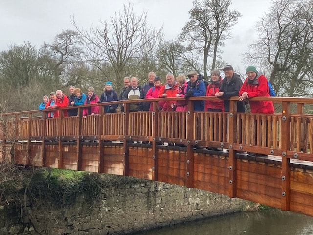
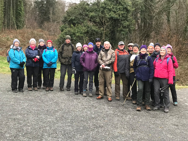
Seventeen Spartans gathered at Malone House. Sunhats, sunglasses and short sleeves were the general attire and even three pairs of shorts. Well done guys. What a relief! Summer in N.Ireland hadn't totally deserted us. We walked to Upper Malone and entered Lady Dixon Park. Having walked around part of the boundary path we made our way through the 10 rose gardens. They were looking well and had mostly recovered from the battering they had taken in recent weeks from the wind and rain. A coffee break was most welcome and pleasant in the Floribunda Rose Garden. On the return route we skirted the Mary Peters track, crossed the Gilchrist Bridge and visited the Terrace Hill Garden. Here we had a view of the Lagan Valley and across to the Barnett Demesne and Malone House where lunch awaited us. Dorothy |
Weds 10th July 2024
Holywood to Crawfordsburn
|
The weather forecast for the day was anything but promising but despite that 8 Spartans turned out to walk from Holywood to Crawfordsburn. Holywood was founded by St. Laiseran in the early 7th Century. In the 12th century an Anglo-Norman Augustin Abbey was built by Thomas Whyte and much of the ruins still remain. The Priory was dissolved on New Years Day, 1541 by Henry VIII with its lands passing into the hands of the O’Neill family and then to Sir James Hamilton, First Viscount Clandeboye who was responsible for setting out the foot print for modern day Holywood.
In the early 19th century Holywood became a popular seaside resort for the growing population of Belfast. It wasn’t long before the wealthy merchants of Belfast recognised the advantages of residing in the town and built large residences, many of which can still be seen today. Holywood became a dormitory town for the growing settlement of Belfast. Its growth was greatly aided by the construction of a railway line. At the centre of Holywood stands a ‘maypole’. The original pole was a ship’s mast donated by a grateful ship’s captain after the town’s folk came to his rescue when he ran aground in ‘Belfast Lough’. Today the town has a population of 12,500. |
Dressed in full protective all-weather gear we left Holywood behind and travelled along the coastal path passing many impressive dwellings. Our route took us past Royal North of Ireland Yacht Club where children were being instructed in the rudiments of sailing. Perhaps there was an Irish or World Champion in the making. The yacht club is one of the largest in NI with over a 1,000 members. The next landmark along the way was the Royal Belfast Golf Club founded in 1881. This is one of the oldest courses in Ireland only predated by the Royal Curragh founded 1858. By my reckoning there are at least four golf courses along the coastal route. |
Making good progress we soon reached the outskirts of Helen’s Bay. Just prior to the village is Grey Point Fort which is one of the best preserved 20th century coastal forts in the British Isles. Although closed to the public for the moment it houses a most unusual hands-on military museum. A number of special commemorative events are held each year. The village of Helen’s Bay is named after Helen Blackwood, Baroness Dufferin and Clandeboye; her family owned the Clandeboye Estate. The bay boasts a long sandy beach blessed with good quality water. It has become popular for wild water swimming and paddle boarding. After Helen’s Bay we walked on to reach Crawfordsburn. In the 17th century Crawfordsburn started life as a place where coaching parties stopped for refreshments and over-night stays in the local inn. The inn still exists today but has been transformed into a luxury hotel and restaurant selling fine food. The village has a population of less than 600 and is a commuter town but unusually for a commuter town Crawfordsburn does not have a railway station but it does have an extensive country park.
After a very convivial lunch in the park cafe we headed back to Helen’s Bay and caught a train back to Holywood. Thanks to everyone who attended.
Walk statistics: - length 7.5 miles, time including breaks 4 hours.
Ray
After a very convivial lunch in the park cafe we headed back to Helen’s Bay and caught a train back to Holywood. Thanks to everyone who attended.
Walk statistics: - length 7.5 miles, time including breaks 4 hours.
Ray
Weds 3rd July 2024
Tollymore Forest

|
|
Trassey Road car park was the starting point for an amble through Tollymore Forest. Along the way to the main forest paths we passed a few points of interest featuring mystery people from the past such as the King’s Grave and Maria’s Bridge. We looped around various paths passing signs for film locations and at one point heard a bit of shouting which we assumed was part of a scene. Saw plenty of camera tech but unfortunately not the elusive actors. The weather held up remarkably well and we were able to picnic at the end. Thanks Kyle for the delicious strawberries and to all who attended. Irene |
Weds 26th June 2024
Divis and the Black Mountain

|
|
With a weather forecast for a fine, dry, sunny and hot day, 20 Spartans gathered at the Divis and the Black Mountain Upper Car Park in anticipation of a “factor 50” rather than an “umbrella” walk. Unfortunately the day’s weather forecast was for the afternoon and not the morning so the Spartans were met with heavy mist, low cloud and light rain on arrival at the car park. The slightly inclement weather however did not deter enthusiasm and all headed off on the Summit Trail in the direction of a well cloaked Divis Mountain. Reaching the summit of Divis the views over Lough Neagh and beyond to the Sperrins had to be imagined rather than seen, however on the descent there was optimism that the mist and low cloud would soon blow over. |
On reaching the Black Mountain visibility was still metres rather than miles, but as we progressed the Ridge Trail paralleling and overlooking the Lagan Valley, the weather lifted and there were cheers as the outline of the Greater Belfast region started to appear. By the time all arrived back at the Rangers Office and Café, the sun was almost splitting the trees and all were able to sit al fresco on the benches with a picnic or refreshments from the Café where the great chat continued.
Thanks to everyone for enduring the inclement weather!
Paul
Thanks to everyone for enduring the inclement weather!
Paul
Wed 19th & Thurs 20th June 2024
Rathlin Island
|
10 Spartans boarded the ferry to Rathlin Island on a very pleasant Wednesday morning. On arrival a short coffee break was taken before the 4.5 mile walk to the West Lighthouse and the RSPB bird sanctuary. The full colony of seabirds was still present including the very cute Puffins. We learned about a conservation programme to eliminate ferrets and rats on the island which pose a very real threat to the nesting birds. The ferrets have been dealt with and the work on the rats starts in September after the seabirds have left the cliffs. A specially trained sniffer dog has been recruited to help. Presumably he can "smell a rat". After a lunch break we headed back to the harbour taking in the spectacular scenery as we went. By now it was getting quite warm and our boots were leaving prints in the softening tar on the road. On our return refreshments were taken at the Manor House where 5 of us were staying the night before the other 5 departed for the return ferry. Probably the best weather of the year so far. Our overnight stay was very comfortable with great food and very pleasant staff.
|
|
Another well-known Spartan Jim Duffy arrived in for dinner off a visiting yacht and a few night caps at the only pub was rewarded by hearing a corncrake in the fields behind the pub.
Thursday morning was a much duller day as we set off to the southern end of Rathlin through what the bus driver called "the lake district" better known locally by the more romantic name Roonivoolin. The road goes the whole way to Rue Point but we went off piste to take in some coastal paths. A short period of light rain didn’t dampen our spirits and Port Ushet was soon in view. This was the first harbour on Rathlin and was associated with smuggling for many years. The return route to Church Bay was via the cliff path on the western side of this leg of the island which on a good day offers spectacular views over Torr Head, Fair Head and along the North Coast. Crossing from the cliff path back to the road our way was blocked by some cows with calves at foot so discretion prevailed and a short diversion avoided any trouble.
Our return route took us past Mill Bay where we observed over a dozen seals hauled out on the rocks to add to the ones we had already seem at Rue Point. After the 6.5 mile walk a well-deserved lunch at the Manor House brought to a conclusion what had been a very enjoyable trip before taking the ferry back to the mainland. Apart from the walks mentioned in this report there are a number of other tracks worth exploring even on a day trip, so if you are interested let me know and I will explore what can be arranged.
Kyle McClintock
Weds 12th June 2024
Portballintrae Circuit


On a rather dull late spring day 11 Spartans arrived in Portballintrae to set off for the Giant’s Causeway and beyond. The group were joined by 2 Canadian guests. Our walk took us from the car park across the wooden bridge over the Bush River and then along its eastern bank. Leaving the river we crossed the dunes in the direction of the rather imposing Runkerry House built by Edward Macnaghten in the 1880’s. Edward had a big family including 6 daughters, none of whom married. Why should they as marriage could hardly lead them to a better house or lifestyle? All 6 siblings lived out their lives surrounded by servants in the 20 bedroom mansion.
In the shadow of Runkerry House is a fisherman’s hut where a man called Neil lived. Neil was a bit too fond of the whiskey brewed at the nearby distillery. One day, not for the first time Miss Florence Macnaghten came across him when he was in a drunken stupor. She challenged him to quit the drink and he answered “I’ll quit if you swim across Runkerry Bay”. She accepted the challenge and completed the swim as reported by the local paper in challenging weather. Neil quit the drink. The annual swim continues to this day.
Just before Runkerry House the path crosses a small stream. Until recently a bridge forded the water but this had been washed away. The local council have recognised the importance of the route and have set aside £20,000 to rebuild it. As yet work has not commenced but fortunately a plank is in place and although a little rickety all Spartans and guests were able to make the crossing. Afterwards we climbed the steep hill adjacent to Runkerry House and walked along the headland eventually encountering another obstacle, namely a set of steps in poor repair. With great care we ascended the steps.
When we reached the Causeway Centre we decided to follow the cliff path to the Shepherd’s Steps which we descended and walking along the meandering path we passed the Giant’s Boot after which we soon reached the Causeway. Legend has it that an Irish giant named Finn McCool created a causeway to cross the Irish Sea to Staffa in Scotland so he could face down his rival, the Scottish giant Benandonner. Conspiracy theorists believe the causeway was the result of specific volcanic forces which happened 60 million years ago. A likely story I must say, but you decide.
From the Causeway some boarded the bus to the centre, the remainder made the steep climb to the ‘Nook’ for lunch. The Nook is found right at the entrance to the Giant's Causeway Visitor’s Centre. The Nook restaurant was once the original Causeway School dating from the 1850's. It closed its doors in 1913 when replaced by the Causeway Memorial School; closing in turn in 1962. The original schoolhouse has been sympathetically restored and now encapsulates all its original Victorian features. It is well worth a visit for light refreshments or a more substantial meal. Leaving the Nook, well fed and watered we headed back along the single track railway which once ran from Portrush to the Causeway, After a mile or so a short detour took us across the fairway of Bushfoot Golf Club and back to our cars in Portballintrae. Walk statistics: 7 miles, time with beaks 4.5 hours, ascent 732 feet and descent 662 feet.
Thanks everyone for your company. Ray
Weds 5th June 2024
Scrabo Country Park and Killynether Wood


|
A large group of 19 Spartans enjoyed their visit to Scrabo Country Park. From the car park we firstly walked into Killynether Wood and made our way down to the small lake where we enjoyed watching a mother coot with her chicks. Then we made our way round to the walled garden and back to the car park. Then it was uphill to the Tower for views of the town of Newtownards before descending to walk round the quarries. We were lucky with the weather - only one shower while we were in the wood and then another at the end just as we came back to the cars. Some of us then went up to Scrabo Golf club for a cuppa and a bit of craic.
A great way to spend a day!! Marian |
Weds 29th May 2024
Broadwater

|
A dry, overcast but relatively warm early summers day saw a grand turnout of 29 Spartans for the Broadwater towpath walk. Gathering at Moira Train Station, the Spartans walked through the countryside along the abandoned canal which is now beautifully overgrown and a haven for flora, fauna and wildlife. A short break was taken at the Aghalee Village Green, then the Spartans ambled some quiet country lanes and roads rising above the canal with views to the Mournes, before dropping back down to the towpath at the derelict Lock Keepers Cottage where some fishermen were patiently casting for a bite. Arriving back at Moira Station after a walk of approx. 8 miles, the Spartans were ready for some refreshments, and most adjourned to a Café in Moira for alfresco nourishment where the criac and conversation continued.
Thanks to everyone for participating. Paul |
Weds 22nd May 2024
The Moat Pad and Adders' Loanin'
|
A dozen of us met in the Lighthouse Road car park. Has anyone any idea why this should be called Lighthouse Road as its so far from the sea ??
The weather was kind & we walked a circuit of about 5.5 miles – along the Moat Pad , Rathfriland Road, Ballymackilreiny Road, Millvale Road and back up Adder’s Loanin’. There are some lovely views of the Mournes & a few fixer-upper properties on splendid sites. Unusually – the path was not wet & muddy ! Then we went along to the Turnip House for lunch. They are not usually open on Wednesdays but were this time as they had some workshops on. We rang ahead to let them know numbers as they as they are so small it would be difficult for them to land in any number of diners. They set us up in the craft room & we enjoyed, soup, homemade wheaten scones straight from the oven, cake & tea/coffee – all yummy & not difficult to pay for. Jessica |
|
Weds 8th May 2024
Glenarm

|
|
We met at Glenarm harbour on a fine dry, bright day. We went up into the disused quarry to get some lovely views out over the village, the bay, and Glenarm castle itself. We walked along Artie’s way , down The Vennel and then up through the forest with nice views across the valley to the Glenarm estate. We walked and talked over almost 8 miles and climbed just over 600 feet. The walk ended in the estate tearoom with some very tasty food.
Isobel
Isobel
Weds 1st May 2024
Castlewellan Forest Park
|
After the last couple of days of torrential rain, today was unbelievably dry and sunny. The walk took us past the site of an old brewery which produced bottled liquor back in the day, though nothing of the buildings is visible now. We passed Mitchell’s Lake on our way to the top of Slievenaslat, stopping at the trig point for a break. From there it was on to the Mountain Lake and downhill to the car park. It was lovely to see the fresh greens of the trees coming in to leaf and swathes of bluebells carpeting the ground. We had coffee/ lunch at the Ark coffee shop. Sitting in the sun with the backdrop of the Mournes rounded off the day nicely. Thanks to all who attended. Irene |
|
Weds 24th Apr 2024
Barnavave Loop
Weds 17th Apr 2024
Tievendarragh Wood and Bohill Forest
|
Almost all of the 24 Spartans assembled in the car park at Tievendarragh Wood confessed that they had driven past literally hundreds of times heading towards Newcastle and the Mournes, but had never set foot in the woods on either side of the Belfast-Newcastle A24. The initial topic of conversation was whether or not to wear over trousers. The 16 who had been out on walks on recent wet Wednesdays did, but the 8 who didn’t still fared rather well as the rain began to ease as we walked a “S” shaped route along the gravel trails of Tievendarragh Wood, stopping briefly at a viewpoint towards the barely visible Mournes.
Over, under or limbo was the choice of how to cross the gate in “stile” onto the busy A24. Crossing the main road, the route led into Bowhill Forest following in district paths through the forest. The group wound the way up the hill to emerge out of the woods to a rocky clearing with views to the west. Fortunately the rain had by now eased to allow for a break with, lovely views overlooking Tannaghmore reservoir toward Slieve Croob and Drumkeeragh. Descending the hill, the route diverted through Bohill Nature reserve before emerging onto Tannaghmore Road, walking south then turning left onto a “loanin”. Emerging back onto the A24 we walked alongside the busy road for a short distance, then crossing the road to returning through the southernmost trail of Tivendarragh Wood to the carpark. |
All but one of the Spartans were sufficiently hungry after 5 miles of walking to repair to “The Stick” at Brennans for lunch followed for some by a famous Brennan’s ice cream. Stephen Gilmore |
Weds 10th Apr 2024
Knockagh
|
10 Spartans met on a wet day at Woodburn Forest, Newtownabbey. Thankfully the rain subsided as we started to walk through the forest. In fact it stopped! However as we decided to try a new route round the upper Wood burn reservoir rather than be exposed to the elements at Knockagh we encountered very bad mud. Undaunted the Spartans walked through the mud and then took an easier route round the lower reservoir. Many adjourned afterwards for a cuppa at Rumours cafe in Carrick. David |
|
Weds 3rd April 2024
Orlock Point to Bangor
On a cold wintery day under a watery sky 8 Spartans met at Bangor Bus station to catch a bus to Orlock. The weather over the few days proceeding the walk had been very wet and conditions under foot were muddy and treacherous. Despite the adverse conditions the group set off to walk to Bangor. Because of the mist the coastal path provided us with limited views but the craic was good and our spirits high. Before long we found ourselves passing the park on the outskirts of Groomsport. Not surprising the the prefabricated homes looked empty.
We paused in Groomsport for lunch before taking the track to Ballymacormick Point. This was a particularly muddy section and it was a pleasure to eventually reach the solid tracks and road of Ballyholme. On reaching Ballyholme at 14.30, we headed to the Starfish Cafe. The cafe serves excellent tea, coffee, scones and tray bakes but be aware the establishment closes at 15.00 hours. After refreshments we headed along the coastal road back to Bangor. Walk statistics:- walk distance 7 miles, walk time including breaks 4.5 hours.
Thank you everyone for your company. Raymond
Weds 27th Mar 2024
Cavehill
|
In hope that the weather would be more favourable than forecast, it was a quality rather than a quantity Spartans turnout that met at Belfast Castle. John, Terry and Paul walked the Cave Hill Trail anti-clockwise from the Castle up through the forest, past the Caves and stopping at McArts Fort to enjoy the view across to Scrabo emerging through the low clouds and mist. A slight detour was taken to achieve the summit of Cave Hill at 1207 ft and then the descent along the well surfaced path towards the Hightown Road was followed. To optimise the vistas over Belfast and the Lagan Valley, Terry suggested the path around the quarry which was well worth it, and without a rain cloud in sight! |
|
Arriving back at the Castle and having managed to dodge the forecast heavy showers, a downpour started just as we were getting into our cars. Perfect timing! A distance just shy of 4 miles and a total ascent of 900 ft. Great chat and craic as ever, and thanks to Terry for the local knowledge! Paul
Weds 20th Mar 2024
Gracehill
|
|
|
Ballymena was the location of our walk , starting at the local garden centre, walking along the River Maine and behind the old Gallagher factory. We stopped in the historic Gracehill village square for a look around. Then we crossed back through Galgorm Castle grounds to wind our way down to the River Braid. We were very lucky with the weather so of course everywhere was looking at its best. Sevenish miles and 2 and three quarters hours of walking time plus the looking about us time…
Coffee and delicious eats finished off the day in that well placed garden centre! Isobel
Coffee and delicious eats finished off the day in that well placed garden centre! Isobel
Weds 13th Mar 2024
Lagan Towpath
|

|
It was a mild but rather damp day when 18 Spartans gathered in the Stranmillis Boat Club car park to walk the second leg of the River Lagan Tow Path dander. The walk took us from Stranmillis as far as the second foot bridge. The start of the walk followed the perimeter track until it reached Bladon Drive. From here we walked the path through Lagan Meadows back to the river and along the tow path. We crossed the recently repaired foot bridge and headed uphill to the Belvoir Forest car park which was once the site of Belvoir House built by Arthur Hill the First Viscount Dungannon. Having been left a considerable inheritance by his uncle, Sir John Trevor, Arthur Hill changed his surname to Hill-Trevor It was here we took a banana break. Crossing the car part our onward route took us in the direction of the Norman Motte dated from 12th-14th century. Sadly today the top is overgrown and the commanding views which it once had are now obliterated. We took the path past the ice house and along the course of the Lagan until it took a sharp right Here the path becomes much wider. We paused for a time in a glorious redwood clearing. This once formed part of the arboretum planted by Arthur Hill-Trevor. Further up the track, on the right was the site of the estate’s orchard. The path continues and passes the now abandoned grave yard which is the last resting place of some members of the Hill Family. Using various tracks we made our way back to the car park where we had a lunch. At the weekend it is possible to purchase coffee, sandwiches and tray bakes et. I from the ‘horse box cafe’ parked here but not today. After lunch we walk back to the bridge and onto the tow path. From here it was an easy dander back to the Boat Club cafe and refreshments.
Thanks everyone for your company. Walk statistics:- distance 6 miles, walk time 3 hours. Ray and Hazel
Thanks everyone for your company. Walk statistics:- distance 6 miles, walk time 3 hours. Ray and Hazel
Weds 6th March
Giant's Ring Circuit
|
The lovely spring sunshine encouraged 28 Spartans to shake off the winter blues and partake in the Giant's Ring walk. We started at the top car park at the Mary Peter's track and followed the path leading down to the Lagan towpath. We walked as far as the Gilchrist bridge and crossed over the river to walk into Edenderry village and on out towards the Giant's Ring and Dolmen. From here we headed down to the Giant's Ring Road and followed the sand-pit trail onto the Minnowburn trail where we stopped at the Terrace Hill garden for a short break and to admire the wonderful view. Continuing along the Minnowburn Trail we crossed over the Edenderry Road and followed the trail along the Lagan until we reached Shaw's Bridge. We then headed up into Barnett's Demesne and made our way to Cafe Nosh at Malone House. What a great welcome we had here - it pays to ring ahead!! They had organised a room for us all to sit in and despite the chaos that a large group causes, the staff dealt with us very efficiently. We were soon tucking into various yummy dishes and enjoying the craic.
|
|
Once finished we headed back out into the sunshine to complete our walk back to the car park at Mary Peter's.
We walked approximately 8 km give or take a few hundred meters (depends on whose walking app is most accurate!!). Marian
We walked approximately 8 km give or take a few hundred meters (depends on whose walking app is most accurate!!). Marian
Weds 28th Feb 2024
Peatlands Park

|
|
Weds 21st Feb 2024
Cregagh Glen & Lisnabreeny
|
|
19 Spartans assembled at the entrance to Cregagh Glen to walk uphill to the Lisnabreeny Rath. This wooded glen is all that remains of a forest that once covered 1000 acres. There are several waterfalls on the river, and the glen contains some mature mixed woodland of sycamore, beech, Scots pine and ash. The side of the Glen was covered in emerging bluebells but as yet no flowers. This would make for a lovely dander during April when the bluebells where in full flower. The Cregagh Glen was once part of the Robb Estate. A grand house once stood close to the top of the Glen and was owned by the Robb family who in turn owned Robbs a large department store situated in Castle Place in Belfast. Many will remember visiting it to see Santa. in 1939 Lisnabreeny House and the 166 acre estate including Cregagh Glen, Lisnabreeny Rath and the site of the American military cemetery was donated to the National Trust. Afterwards for a short time the ‘house’ was run as a youth hostel but was handed over to the American forces when they joined the allies in 1942. After the war it became a ruin but was rescued by a group of parents in the ‘All Together Organisation’, founders of integrated school movement and became part of the Lagan College complex. The group took the time to detour to the American Cemetery where 148 American servicemen were buried between 1943 and 1945. Ironically nearly half of those interred died as a result of natural causes, road or training accidents and most were airmen. In 1948 their bodies were exhumed by a team of 5 morticians and re-buried in Cambridge or back in the States. We retraced our steps back to the glen and when we emerged from its dim dampness we headed onwards and upwards through the grounds of Lisnabreeny House to Lisnabreeny Rath on the summit of the hill. As we ascended the hill we had spectacular views over Belfast. Over 1000 years ago the Rath was the homestead of a farming family The Rath once consisted of a large circular earth bank topped with a timber stockade with a ditch on the outside. The rath would have contained round huts and would have been a containment for animals typically cattle which could have been herded in for protection from marauding rustlers or wild animals. So far our walk had been a two mile uphill climb. After a banana break it was time to make the return journey following almost the same route.
After the walk a number of Spartans made for Cafe Nero in Sainsbury’s for more talk and well deserved refreshments. Thanks to all the Spartans.
Walk statistics :- distance 5.6 miles, walk time 3.5 hours, ascent 836 feet. Raymond Smyth
After the walk a number of Spartans made for Cafe Nero in Sainsbury’s for more talk and well deserved refreshments. Thanks to all the Spartans.
Walk statistics :- distance 5.6 miles, walk time 3.5 hours, ascent 836 feet. Raymond Smyth
Weds 14th Feb 2024
Dundrum

|
On Valentines Day 23 Spartans met up in Dundrum for a walk in the Sand Dunes, Beach and Forest of Dundrum Bay. The weather was good to us and we managed to avoid the promised rain showers forecast for the day. The usual fan club of hecklers turned up (you know who you are!!) and instilled lots of confidence in the Leader with comments like “Do You know where you’re going?”, “Have we been here before?”. But that’s okay I will get my turn … eventually 😊 A leisurely lunch in the Sand Dunes then onwards down the Beach. Turning to head for the small Forest. At this point 23 became 19 as 4 Spartans took a short cut to the end of the walk. All in all, a good day was had. John
|
Weds 7th Feb 2024
Somme Centre to Crawfordsburn
|

|
|
24 of us met up at the Somme Centre carpark, Conlig. It was a lovely day – dry, a bit sunny, a bit nippy but great for walking.
From the carpark we headed off up through the lead mines & across the Clandeboye Golf Course up to Helen’s Tower. Then the route was down past the ponds & along a short bit of the Crawfordsburn Road - with care as it is pretty busy ! From there we followed the track through the woods, past the Blackwood Golf Centre & across the Ballysallagh Road, to join the Clandeboye Carriageway as far as the Belfast Road. Then we walked into Crawfordsburn village & down through the Country Park to the Woodlands Café for a bite of lunch.
As this was an end-to-end walk, a number of people used public transport (train & bus) while other arranged lifts.
My phone says we walked 11.3 kilomteres (7 miles) & 17,200 steps in about 3 hours. Thanks to everyone who took part – it was a fun day out. Jessica
Weds 31st Jan 2024
Cairn Wood
|
|
19 Spartans met on a rather breezy winters day at Cairn Wood Forest. The Met Office had issued a ‘yellow warning’ for the day so just in case alternative walk arrangements were put in place. As it was it was decided to keep to our original plan. Our route took us around the perimeter of the forest. In places fallen trees blocked our path but nothing too serious. The route we followed is well documented in other walk reports; 25.01.23 and 15.06.22. so no need to repeat myself.
Towards the end of the dander we encountered Angus the ‘bird whisperer’ of Cairn Wood. Angus has been feeding the birds for 30 years and knows everything there is to know about the forest. He leaves little piles of bird seeds at certain places around the lower paths of the forest and when he whistles the birds flock to feed. He also informed the group there was a colony of red squirrels at the top end of the wood but feared if a proposed development of 300 houses, just a few hundred yards from the forest was granted permission the squirrel population would be wiped out. He went on to tell us he was probably the last post war person to have descended into the dugout which was a World War Two lookout post. The forestry service feared for the safety of the public and piled trees over the entrance so effectively sealing it.
Walk statistics:- A circular route distance 4.5 miles, walk time 2.5 hours, ascent 600 feet
Following the walk some Spartans retired to McKees Farm-shop and Cafe for some well earned refreshments. Raymond Smyth
Weds 24th Jan 2024
Montalto

|
|
Weds 17th Jan 2024
Scrabo Hill and Killynether Wood
|
|
Weds 10th Jan 2024
CSL to Stormont

|
A bumper crop of 28 Spartans enjoyed a very pleasant 5 mile walk on a beautiful winter’s day in East Belfast. We met up at C S Lewis Square in the inner east and made our way to Stormont via the Comber Greenway. The Greenway provides a surprisingly tranquil route through an urban environment and the Stormont estate was looking splendid in the winter sunshine. After a circumnavigation of the estate, the walk finished at the picnic tables close to the main gates where the chat continued over lunch. Graeme |
|
Weds 3rd Jan 2024
Bangor to Holywood
|
|
Twenty-seven Spartans met on Wednesday 3rd January 2024 at Pickie Café in Bangor and walked 16km along the coastal path towards Holywood. We were glad to get some exercise after the holidays. The day was bright and the chat was good. We stopped at the Woodlands Café in Crawfordsburn Country Park for lunch. A good start to the New Year. We finished at Holywood to get the trains home. Jackie.
